About Irrigation Department Directorate of Ground-Water Andhra Pradesh

Introduction
Objectives
Functions
About Andhra Pradesh
Citizens Charter
Trends In Groundwater Development
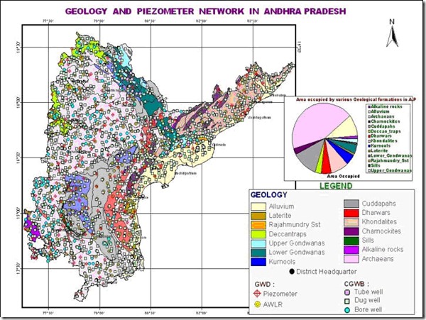
Geology and Piezometer network in Andhra Pradesh
Programs taken up by Groundwater Department
Externally Aided Projects
Awareness programmes ans data dissementation
AP WALTA
Organogram
Addresses of Incumbents
Status Of Works Taken Up By Ground Water Department
Statistics of AP
District wise & Water levels in Andhra Pradesh
Depth to Groundwater levels in Andhra Pradesh -map
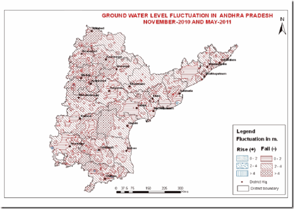
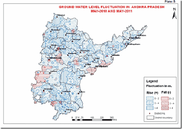
Groundwater level fluctuations in Andhra Pradesh -maps

INTRODUCTION TOP
Mandate of the Department

Groundwater department was established in March-1971, as per the agreement entered into by Government of India with World Bank (IDA) to:

  • Channalise financing Minor irrigation schemes based on scientific estimation of groundwater resource.
  • To evaluate Minor irrigation schemes like sinking of wells and energizing of wells with pump sets.

About the Department

    • Headed by Director at the State level and Deputy Director at the District level.
    • Multi-disciplinary organization.
    • Declared as the nodal agency for all ground water related activities in the state.
    • Co-ordinates with organizations related with ground water development.
    • Closely associated with scientific organizations & universities.
    • Of late, the emphasis of the Department shifted from groundwater development to Management for scientific planning and systematic development.

OBJECTIVES TOP

The main goal of the Ground Water Department is scientific development, systematic management and optimal monitoring of groundwater resources for sustainability.

FUNCTIONS TOP

  • Estimation of ground water resources.
  • Delineation of potential zones.
  • Investigation for selection of sites for :
    • Wells
    • Recharge structures
    • Exploratory drilling
  • Drilling of exploratory-cum- production bore wells and piezometer.
  • Monitoring of ground water levels and quality through a network of observation wells and piezometers.
  • Conjunctive use studies.
  • Arial photo and satellite imageries interpretation.
  • Monitoring and evaluation of watersheds and artificial recharge structures from groundwater point of view.
  • Externally aided projects:
    • Hydrology project (Phase- I completed, Phase- II On going)
    • Indo-French project ( completed )
    • Nalgonda pilot project under APWELL, Netherlands assisted ( completed )
    • APERP (Completed)
    • AP – III irrigation project ( completed )
    • AP Community based tank management project ( On going)
    • AP Community Based Groundwater Management ( yet to start)
  • Investigation for according clearance for LI schemes.
  • Survey for classifications of soils for canal construction.
  • Investigation for industries/mines for environmental clearance.
  • Study feasibility and effect of sand mining on groundwater regime.
  • Technical advise for implementation of WALTA.
  • Preparation of reports, notes, periodicals and maps for dissemination of data.
  • Creating awareness on groundwater management at grass root level.
  • Special studies on impact of artificial recharge structures.

ABOUT ANDHRA PRADESH TOP

I. Introduction
Andhra Pradesh with a total geographical area of 2.744 lakh sq.kms. is the third largest St
ate in the Country with a population of about 7.00 crores, which depends mainly on agriculture. Out of the total geographical area of 2.744 lakh sq.kms. about 53 per cent is cultivable land. The growth rate of population as per the previ­ous census (1991) records is 21 per cent per decade on an aver­age. Assuming the same growth rate, the total population of A.P. State by the year 2020 AD will increase to 11.39 Crores. The urban population in Andhra Pradesh has increased to 178.87 lakhs from 62.74 lakhs during the last three decades. Due to rapid industrialization and considering the previous average decadal growth the Urban population may increase to 603 lakhs by 2020 AD.
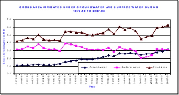
The normal annual rainfall of A.P.State is 940 mm, which remained nearly constant during the past quarter century. Similarly the change in the normal annual rainfall during the next quarter century to come may be negligible. The gross area irri­gated in Andhra Pradesh under all sources is around 6.28 million hectares, of which surface water accounts for 3.11 million hec­tares and the balance 3.17 million hectares comes from ground­water sources.

II. Availability of Groundwater
From the groundwater point of view, rock formations in the State can be classified into three distinct categories of (a) hard rocks, (b) soft rocks and (c) alluvial formations. Ground­water in these rocks occurs under water table, semi-confined or confined conditions. Groundwater is present in secondary porosi­ty of the host rocks limited to the weathered and fractured zones; joints and bedding planes etc., In the soft rocks and alluvium, the inter granular porosity contributes towards occur­rence and movement of groundwater.

Nearly 85% of the State is underlain by hard rocks and the chief contributors of groundwater in these rocks are the fractured systems. These fractured sys­tems as mentioned above are not uniformly distributed and have limited aerial and depth extent.

Rainfall is the source of recharge to groundwater and during the last decade this source has become erratic and some times very low. The number of rainy days has also come down. Thus the recharge to groundwater bodies has come down. Apart from this people are resorting to use groundwater more often because, it is economical, easily available and consumes less time to ground a project, in view of the limited surface water resources and their uneven distribution. Thus the strain on groundwater aquifers mostly in upland areas is increasing day by day.

III. Future Scenario
Based on statistics for the resource at year 2020 AD the number of wells will be around 36 lakhs mostly deep bore/tube wells, irrigating about 36 lakh hectares. The corre­sponding stage of groundwater development will be around >85%. However balance potential will be restricted mostly to command areas.

CITIZENS CHARTER:TOP

Under Citizens Charter, the department undertakes Customer Services, attends to Public Grievances related matters and tries to redress them from time to time.

TRENDS IN GROUNDWATER DEVELOPMENT TOP

  • During the last three decades:
  • Well population increased from 8.0 to 25.0 lakhs.
  • Average annual growth rate of well population in the state is about 50,000 wells per year.
  • Area irrigated through groundwater increased from 10 to 28 lakh hectares.
  • This constitute about 50% of the total area irrigated.
  • About 80% of the drinking water needs are met through groundwater.

CHANGING GROUNDWATER SCENARIO IN HARD ROCK HYDRO SYSTEMS

Years

Type of Wells

Yield

Well density/sq.km

1982

Dugwells

60 – 150 cu.m

< 5

1983-84

Dugwells/ Dug cum borewells

60 – 150 cu.m

5 – 10

1984-94

Dugwells/ borewells

40 – 100 cu.m / 150 – 600 lpm

> 10

1994-98

Borewells/ Dug cum borewells

50 – 400 lpm / 30 – 60 cu.m

> 15

1998-08

Borewells/ Few dug cum borewells

50 – 150 lpm / 20 – 40 cu.m

> 20

GROSS AREA IRRIGATED UNDER DIFFERENT SOURCES-Graph
clip_image001

GROUNDWATER MONITORING NETWORK:

  • Water levels are regularly monitored to know the changes in groundwater regime.
  • Network of dug wells established in 1974 to monitor shallow depth water level.
  • Network :
    • command area – 1404 wells
    • non-command area – 1582 wells
    • stream flow check points – 132
      [stream flow check points established to monitor base flow in streams and rivers]
  • Phenomenal growth in 2 decades in the no. of extraction structures resulted in deepening of water levels.
  • As a result during 1998 – 2000 period 1,017 Piezometers established under HP to monitor deeper aquifers
  • 903 Piezometers are installed with automatic water level recorders, rest are monitored manually Water levels recorded every 6th hourly & data received once in every month.

GEOLOGY & PIEZOMETER NETWORK IN A.P TOP
clip_image002

COMMAND AREA DEVELOPMENT
Department takes up studies under four major projects commands to:

  1. Delineate areas already water logged and prone to water logging.
  2. Recommend conjunctive use of both surface and ground water
  3. Suggest other suitable remedial measures to improve productivity

WATER QUALITY

  • The department initially had 3 W.Q. labs at Hyderabad, Rajahmundry & Kadapa, where analysis of 13 parameters was done
  • Under world bank assisted Hydrology project, the existing labs were upgraded to level II+ & level II and number of labs were increased to six.
  • Level II+ lab at Hyderabad is capable of analysing 72 parameters.
  • Level II labs at Kadapa, Kurnool,Vizag, Rajahmundry & Karimnagar are capable of analysing 30 parameters.
  • Job work was taken up for analysing samples from NGRI, farmers in Rajahmundry area besides analysing samples from departmental OB wells & piezometer network.

PROGRAMS TAKENUP BY THE DEPARTMENTTOP

Groundwater Management

Estimation

  • National water policy enunciates periodic assessment of groundwater resource for quantification, sustainable development and management.
  • The State is divided into 40 drainage basins and 81 sub basins of major and minor rivers.
  • These 81 sub basins are further divided into 1229 groundwater micro basins of 100 to 300 square kilometers size based on local drainage, geomorphology and hydrogeology.

Assessment of Groundwater resources

  • Groundwater estimation is done on a basin approach.
  • Revised Estimation during 2007 with 2006 data.
  • Type of Groundwater micro basins identified: Over Exploited – 132, Critical – 89, Semi-Critical – 175 and Safe – 833
  • Due to changing groundwater scenario and addition of more than 50,000 extraction structures every year, it is proposed to take-up revision of estimates at periodic intervals as envisaged in the “National Water Policy

CATEGORISATION OF BASINS IN A DISTRICT

SL.No

District

NO.OF BASINS IN DIFFERENT CATEGORIES

Safe

SC

Critical

OE

TOTAL

1

Srikakulam

18

0

0

0

18

2

Vijayanagaram

24

0

0

0

24

3

Visakhapatnam

42

0

0

0

42

4

East Godavari

52

0

0

0

52

5

West Godavari

33

6

1

0

40

6

Krishna

52

1

1

3

57

7

Guntur

62

1

0

1

64

8

Prakasam

47

7

2

6

62

9

Nellore

37

5

2

1

45


Andhra Total

367

20

6

11

404

10

Chittoor

37

15

13

10

75

11

Kadapa

20

25

15

17

77

12

Anantapur

24

22

12

41

99

13

Kurnool

72

3

1

4

80


Rayalaseema Total

153

65

41

72

331

14

Mahabubnagar

40

12

3

2

57

15

Rangareddy

10

9

8

13

40

16

Sangareddy

29

11

4

9

53

17

Nizamabad

23

11

9

5

48

18

Adilabad

30

7

0

1

38

19

Karimnagar

45

8

3

6

62

20

Warangal

37

7

7

10

61

21

Khammam

65

3

1

1

70

22

Nalgonda

34

22

7

2

65


Telengana Total

313

90

42

49

494


State Total

833

175

89

132

1229


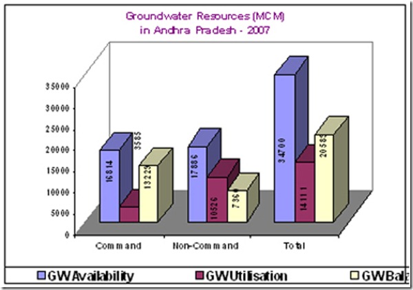
GROUNDWATER RESOURCE IN ANDHRA PRADESH
clip_image003

EXTERNALLY AIDED PROJECTS TOP

Externally aided projects are of great help to the Ground Water Department in enhancing its capabilities for furthering the development and management of Ground Water Resources in the State.

HYDROLOGY PROJECT-I (completed)

The World Bank Assisted Hydrology Project has been successfully implemented by the Government of Andhra Pradesh since 1996 on words with a basic project cost of Rs.14.81 crores and revised to Rs.31.00 crores.

This project’s objective is to improve the institutional and organizational arrangements, technical capabilities and physical facilities available for measurement, validation, collation, analysis, transfer and dissemination of Hydrological, Hydro meteorological and Water Quality data for basic water resource evaluation.

The project components were aimed at:

  • Improving the observation well network for monitoring of water levels and quality.
  • Upgrading of chemical laboratories.
  • Establishment of Computerized data centers.
  • Enhancing the technical capabilities of departmental personnel by providing specialized trainings.

Implementation of the project has resulted in

  • Collection and monitoring of 6 hourly water level data through 1017 purpose built piezometers and 904 DWLR’s
  • Primary validation and analysis of the data at 22 District Data Centres.
  • Secondary validation and analysis of the data by District Data Centres.
  • Final validation, preparation of periodicals and reports at the State Data Centre for planning and better management of ground water resources.
  • Analysis of water samples upto 30 to 70 parameters at the level II and level II + quality labs respectively established at 6 locations.
  • Creation of successful HIS.
  • Upgradation of the skills of the Officers in handling sophisticated equipment, software, data collection, validation, and analysis and data management.
  • Better understanding of the ground water regime. The data generated is being used in the state for implementing the water management programmes for drought proofing measures and categorization of areas for taking up recharge measures. For effective implementation for various programmes the analyzed data on groundwater in relation to causative factors is being furnished to all the implementing agencies and the people at larger through monthly reports and brochures.

HYDROLOGY PROJECT-II (on going)

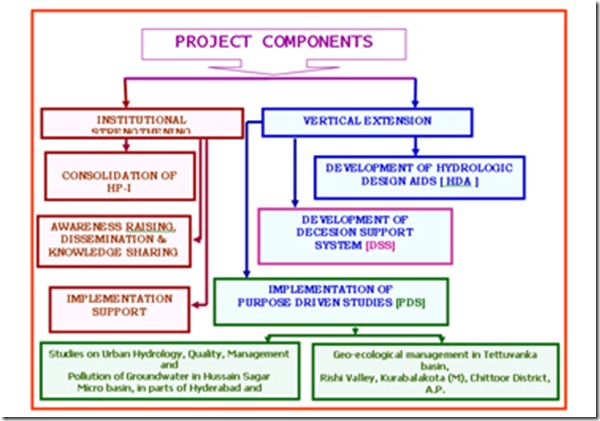
World Bank Assisted Hydrology Project Phase-II is a sequel to Hydrology Project-I, will build on and expand development of a comprehensive Hydrological Information System (HIS), for improving access and use by user departments, civil society and other data users in the sector, thereby intensifying the use of HIS in effective and efficient water resources planning and management.

The project development objective will be to extent and promote the sustained and effective use of the HIS by all potential users concerned with water resources planning and management, both public and private, thereby contributing to improved productivity and cost effectiveness of water related investments.

Project components related to AP Ground Water

– Institutional Strengthening

Rs.2.7102 Cr.

– Vertical Extension

Rs.4.5901 Cr.

– Recurrent Cost

Rs.3.5025 Cr.

-Total:

Rs.10.8028 Cr.

clip_image004

ROLE OF HYDROLOGICAL DATA USERS GROUP (HDUG) & HYDROLOGICAL INFORMATION SYSTEM (HIS)

The World Bank funded Hydrology Project Phase-II is being implemented in the state.
The implementing agencies Surface Water and Groundwater are responsible for execution of the activities as agreed to at the time of finalization of project proposals with World Bank and as envisaged in the Project Implementation Plan (PIP of the project). One of the critical issue related to the implementation of the project as indicated by Secretary to Government of India, Ministry of Water Resources, New Delhi vide their letter addressed to Chief Secretary to Government of Andhra Pradesh D.O.No. 13/1/2008/B&B/1248, Dt: 09.05.2008 is that.

“Organization of dissemination workshop to inform others including the policy makers the importance of having good quality data and information”

“Dedicated Monitoring and Evaluation focal staff to start working towards assessing the performance of HIS”.
It is in this context that in assembling the HIS have constituted separate HDUG representing the current and potential users of data.
The overall functions of setting up state level Hydrology Data Users Group (HDUG) is:

  • To provide a common platform for discussions between Hydrology Data Users and data providers.
  • To create awareness amongst users about HIS data and educate them on the potential and limitations of HIS.
  • To understand, analyze and update information on the changing needs of data users from macro level perspective.
  • To review and recommend additions / deletions in the data collection networks and related HIS, if appropriate.
  • The HDUGs will facilitate to the users on data collection, use of hydrology data, water conservation and hold public awareness workshops.

Originally Hydrological Data Users Group constituted during HP-I vide
G.O. Rt.No.1384, I&CAD (Genl.IV-2) Dept, dt:12.12.07 with 21 members and the same is expanded to 51 members.

Apart from the above Govt. of A.P. accorded permission for formulation of District Level HDUG under HP-II, under the chairmanship of District Collector. The objective is to create awareness among users about HIS
data and educate them on the potential and limitation of HIS. So far 16 District HDUG meetings were conducted.

AWARENESS PROGRAMMES & DATA DISSEMINATIONTOP

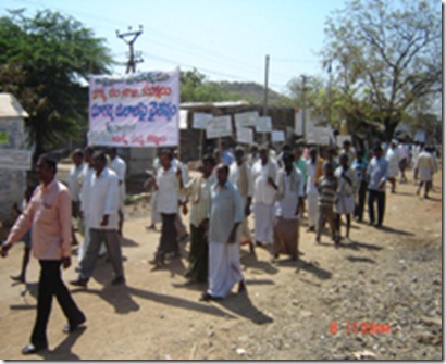
APGWD creating awareness among farming community and water users about the management of water resource available in their areas.

clip_image005

clip_image006

Sl.No

Type of Data

Frequency

Period of data availability

Data Points available for dissemination

1

OB Wells

Bi-monthly (Jan,Mar, May,July, Sept.and Nov)

1974 to till date

1,13,760

2

Piezometer with DWLRs

6 hourly

From 1998-99 to till date

81,92,016

3

Piezometer Manual

Monthly

-do-

12,312

4

Water Quality Data

Pre and Post monsoon periods

-do-

50,734

DISSEMINATION OF DATA
The data is being disseminated to various Government organizations, Research institutes, Universities NGO’s and above all to each and every village as per their need. The status on Groundwater level is being disseminated to District administration, as well as all water related departments for planning purpose.

This department has provided water levels status, water quality data, groundwater potentials etc., to
I. Irrigation projects

    1. Dummugudem L.I.Scheme
    2. Polavaram project
    3. Pushkara L.I.Scheme
    4. HNSS command
    5. GNSS command
    6. Kalwakurthy L.I.Scheme
    7. Nettampadu L.I.Scheme
    8. Vamsadhara
    9. Sripada Sagar
    10. Priyadarshini Jurala Project
    11. Nagarjuna Sagar Project etc.,

II. Organisations like

  1. IWMI 2. EPTRI 3. APSRAC 4. CESS etc 5. WAPCOS etc.,

III. Research scholars and M.Tech students from

  1. Osmania University,
  2. Andhra University,
  3. Srikrishnadevaraya University
  4. J.N.T.U etc., and Scholars, Students approached individually etc.,
  5. Earth Institute, Columbia University, USA etc
  6. Annamalai University, Chennai etc.,

IV. To many individual students, consultants who are working on groundwater related studies.

Abstract of User charges / Data charges for providing water level, water quality data, GEC data and Maps to different users

S.No

Type of Data

NGOs/ Research Institutions

State / Central Govt. Organisations

Students / Reseach Scholars

1

Water level data for Piezometers / General Observation Wells

Rs. 20/- per data point

Rs. 10/- per data point

Rs. 5/- per data point

2

Water Quality Data (Major cations and anions)

Rs. 70/- per sample

Rs. 35/- per sample

Rs. 17.50/- per sample

II. GEC Data:
1. State / District report / Mandal / Basin report: Rs. 1,500/- (GEC estimation report)
2. Village wise data of Mandal / Basin: Rs. 50/- (Hard copy)
3. Village wise data of Mandal / Basin: Rs. 100 /- (Soft copy)
4. Village wise data of Mandal / Basin: Rs. 150/- ( Both hard and soft copies)
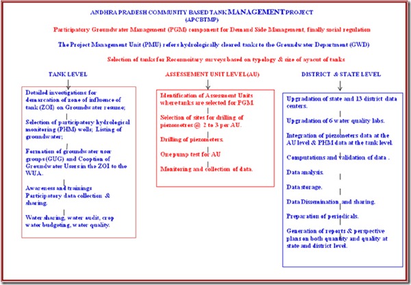
A.P. COMMUNITY BASED TANK MANAGEMENT PROJECT

It is a World Bank and Govt. of India assisted multi dimensional project for restoration of Minor Irrigation tanks where in groundwater component has been included. It envisages demarcation of zone of influence of the tanks and management of groundwater by the community. The Groundwater component outlay is Rs 40 crores spread over 5 years from 2007-08 onwards. About 1200 MI tanks covering 300 groundwater assessment units is likely to be covered under the project

clip_image007

AP WALTATOP
Policy:

An act to promote water conservation and tree cover and regulate the exploitation and use of groundwater & surface water for protection and conservation of water sources, land and environment and matters connected therewith, or incidental thereto.

Salient Features:

  • Registration of wells
  • Prohibition of water pumping in certain areas
  • Need for permission to sink wells near drinking water source
  • Prohibition of commercial exploitation in certain areas
  • Prohibition for development in over-exploited areas
  • Protection of public drinking water sources
  • Registration of drilling rigs
  • Closure of wells in case of contravention of any of the provisions of the act
  • Promoting rainwater harvesting
  • Re-use of water
  • Prohibition of water contamination

Walta – 2004( amendments)

  • Provision for Divisional Authority
  • All well sites to be selected by Ground water dept. or geologists registered by the dept.
  • Rig owners should drill site only after obtaining report from hydrogeologist.
  • Insurance mandatory before taking up for drilling.

RAIN WATER HARVESTING FOR ARTIFICIAL RECHARGE

Simple low cost methods are suggested to collect and store runoff water, from the roof tops of buildings, road surfaces, municipal parks, school play grounds, stadiums, air ports etc, in recharge pits for artificial recharge. Such measures help in reducing the urban runoff, decrease pollution of groundwater and increase the groundwater recharge which facilities to augment the yields of wells. The methods suggested are water spreading, recharge through pits, trenches, wells, shafts and directly diverting runoff water into the existing wells .

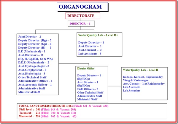
ORGANOGRAM TOP
clip_image008
ADDRESSES OF THE INCUMBENTS TOP

Sri B.M.MURALI KRISHNA RAO, M.Tech,F.I.E, C.Eng(I)
Director,
Ground Water Department,
8th floor, B Block,
BRKR Govt.Offices Complex,
Hyderabad-500 063.
Phone: Office: 040-23223220, 23222671
Fax: 040-23225602.
E-Mail: apsgwd@sify.com

STATUS OF WORKS TAKEN UP BY GROUND WATER DEPARTMENT TOP

The progress for the Year (2011-2012)

ITEM

Annual Targets for
2011-12

Year ( 2011-12)

Targets

Achievement

Investigation of sites for wells & recharge structures

16550

1194

1558

Monitoring of Water levels and Water Quality

31562

4159

4363

Drilling

300

0

0

The Financial allocations & Expenditure during 2010-2011, financial year (2011-2012) (Rs.lakhs)

S.No

Head/ Scheme

Budget allocation for 2010-11 (Rs in Lakhs)

Budget Allotment
(2010 – 2011)

Expenditure Quarter – (up to the end of March, 2011)

1

Non-plan

1788.93

< p>1785.65

1685.24

2

Plan including Hydrology Project

2900

2414.92

1704.73

3

CAD-Plan

108.16

97.16

101.73

STATISTICS OF ANDHRA PRADESH TOP

Average rainfall

940 mm

Total quantity of water

258 bcm

Total surface & groundwater available

110 bcm

Total surface & groundwater utilizable

80 bcm

DISTRICT WISE WATER LEVELS IN A.P TOP

DISTRICT WISE WATER LEVELS IN A.P

GOVERNMENT OF ANDHRA PRADESH

GROUND WATER DEPARTMENT

COMPARISON OF AVERAGE DEPTH TO WATER LEVELS -MAY- 2011

SL.
NO.

DISTRICT

AVERAGE DEPTH TO WATER LEVEL in mbgl

FLUCTUATION IN m. BETWEEN MAY-11 IN COMPARASION TO

May-10

Nov-11

Apr-11

May-11

Nov-11

May-10

Apr-11

1

SRIKAKULAM

7.20

2.67

5.72

5.89

-3.22

1.31

-0.17

2

VIZIANAGARAM

5.58

1.73

4.62

4.20

-2.47

1.38

0.42

3

VISAKHAPATNAM

8.31

3.07

5.69

5.70

-2.63

2.61

-0.01

4

EAST GODAVARI

9.81

5.15

7.66

7.83

-2.68

1.98

-0.17

5

WEST GODAVARI

16.43

10.74

13.36

13.77

-3.03

2.66

-0.41

6

KRISHNA

11.79

5.40

8.23

8.65

-3.25

3.14

-0.42

7

GUNTUR

6.21

2.69

4.48

4.93

-2.24

1.28

-0.45

8

PRAKASAM

11.84

3.97

7.42

8.40

-4.43

3.44

-0.98

9

NELLORE

5.64

1.94

3.87

4.44

-2.50

1.20

-0.57

COASTAL ANDHRA REGION

9.20

4.15

6.78

7.09

-2.94

2.11

-0.31

10

CHITTOOR

16.78

9.64

12.89

13.82

-4.18

2.96

-0.93

11

KADAPA

15.78

7.92

10.79

11.63

-3.71

4.15

-0.84

12

ANANTHAPUR

15.02

9.71

12.71

12.90

-3.19

2.12

-0.19

13

KURNOOL

10.58

6.05

9.51

9.18

-3.13

1.40

0.33

RAYALASEEMA REGION

14.54

8.33

11.48

11.88

-3.55

2.66

-0.40

14

MAHABUBNAGAR

12.27

8.11

11.28

11.71

-3.60

0.56

-0.43

15

RANGAREDDY

13.57

6.08

11.40

12.03

-5.95

1.54

-0.63

16

MEDAK

20.66

11.35

17.44

16.24

-4.89

4.42

1.20

17

NIZAMABAD

16.15

7.47

10.87

11.98

-4.51

4.17

-1.11

18

ADILABAD

14.38

5.26

8.77

9.67

-4.41

4.71

-0.90

19

KARIMNAGAR

13.36

5.29

8.58

9.00

-3.71

4.36

-0.42

20

WARANGAL

12.35

4.90

8.23

8.50

-3.60

3.85

-0.27

21

KHAMMAM

9.69

5.10

7.15

7.52

-2.42

2.17

-0.37

22

NALGONDA

11.84

6.18

8.40

8.82

-2.64

3.02

-0.42

TELANGANA REGION

13.45

6.64

10.11

10.61

-3.97

2.84

-0.50

Andhra Pradesh

12.06

5.93

9.05

9.40

-3.47

2.66

-0.35

HYDERABAD CITY

10.23

5.02

9.00

10.73

-5.71

-0.50

-1.73

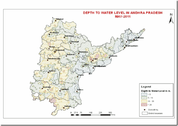
Depth to Ground Water Levels in Andhra Pradesh-Map TOP

clip_image009

Ground Water Level Fluctuations in Andhra Pradesh-MapsTOP

clip_image010

clip_image011


Source: APOnline – Organisation Info
Leave a Reply

Your email address will not be published. Required fields are marked *