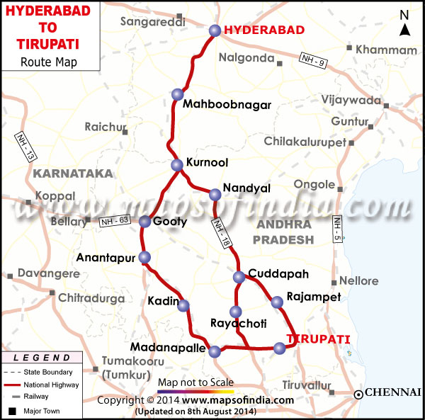
|
The total distance travelled from Sadasivpet to Tirupati is 612.79 Km |
||||
|
Break-Up Route |
||||
|
From |
To |
Distance |
||
|
Sadasivpet |
Sangareddi |
14.04 Km |
NH 9 |
|
|
Sangareddi |
Kundi |
6.72 Km |
NH 9 |
|
|
Kundi |
Patancheru |
17.14 Km |
NH 9 |
|
|
Patancheru |
Lingampalli |
6.07 Km |
NH 9 |
|
|
Lingampalli |
Hyderabad |
23.93 Km |
NH 9 |
|
|
Hyderabad |
Umdangar |
14.48 Km |
NH 7 |
|
|
Umdangar |
Timmapur |
18.78 Km |
NH 7 |
|
|
Timmapur |
Shadnagar |
8.92 Km |
NH 7 |
|
|
Shadnagar |
Farooqnagar |
4.61 Km |
NH 7 |
|
|
Farooqnagar |
Balanegar |
8.74 Km |
NH 7 |
|
|
Balanegar |
Rajapur |
10.41 Km |
NH 7 |
|
|
Rajapur |
Jadcherla |
9.94 Km |
NH 7 |
|
|
Jadcherla |
Badepalle |
3.43 Km |
NH 7 |
|
|
Badepalle |
Buthpur |
11.33 Km |
NH 7 |
|
|
Buthpur |
Musapet |
14.6 Km |
NH 7 |
|
|
Musapet |
Udakat |
12.88 Km |
NH 7 |
|
|
Udakat |
Kothakota |
13.16 Km |
NH 7 |
|
|
Kothakota |
Sugar |
18.03 Km |
NH 7 |
|
|
Sugar |
Kurnool |
57.86 Km |
NH 7 |
|
|
Kurnool |
Narnuru |
11.44 Km |
NH 18 |
|
|
Narnuru |
Varakullu |
6.08 Km |
NH 18 |
|
|
Varakullu |
Kalava |
11.2 Km |
NH 18 |
|
|
Kalava |
Panem |
25.16 Km |
NH 18 |
|
|
Panem |
Nandyal |
18.76 Km |
NH 18 |
|
|
Nandyal |
Sirvel |
17.14 Km |
NH 18 |
|
|
Sirvel |
Allagada |
18.37 Km |
NH 18 |
|
|
Allagada |
Chagalamarri |
23.41 Km |
NH 18 |
|
|
Chagalamarri |
Duvvuru |
15.34 Km |
NH 1 |
|
|
Duvvuru |
Maidukuru |
17.67 Km |
NH 18 |
|
|
Maidukuru |
Khajipeta |
7.96 Km |
NH 18 |
|
|
Khajipeta |
Chennur |
13.85 Km |
NH 18 |
|
|
Chennur |
Cuddapah |
11.31 Km |
||
|
Cuddapah |
Kanamalopalle |
11.47 Km |
||
|
Kanamalopalle |
Vontimitta |
14.03 Km |
||
|
Vontimitta |
Nandalur |
20.37 Km |
||
|
Nandalur |
Rajampet |
8 Km |
||
|
Rajampet |
Pullampet |
7 Km |
||
|
Pullampet |
Reddipalle |
11.84 Km |
||
|
Reddipalle |
Koduru |
15.03 Km |
||
|
Koduru |
Settiguata |
9.47 Km |
||
|
Settiguata |
Renigunta |
33.67 Km |
||
|
Renigunta |
Tirupati |
9.15 Km |
||
|
Total Distance Travelled |
612.79 Km |
|||
|
Cities |
||||
|
Place Name |
State |
|||
|
Sadasivpet |
Andhra Pradesh |
|||
|
Andhra Pradesh |

Source:
http://www.mapxl.com/highway-path-finder/map_routing.phtml?config=routing
http://www.mapsofindia.com/hyderabad/hyderabad-to-tirupati.jpg
Road :
Tirupati is connected by road to all the major towns and cities of South India.
It is:
704 Kms from Hyderabad (via Suryapeta, Vijayawada, Guntur, Gudur & Sri Kalahsthi)
617 Kms from Hyderabad (via Kurnool, Cuddapah & Bakarapeta)
Tirupati is 562 km from Hyderabad (via Kurnool, Cuddapah and Kodur).
APSRTC runs daily buses between Hyderabad and Tirupati. The types of buses are: Express/ Luxury/ Hi-tech/ AC Sleeper Coach.
The AC Sleeper Coach is comfortable as the bus is fitted with Air Suspension for effective shock absorption. Magazines and bedding are provided free of cost. Snacks, soft drinks and mineral water are provided against payment. There is an attendant to serve passengers. The fare is INR 450.00 per head.
Walk Way to the Tirumala
- Many pilgrims walk the 16km (24km by bus) up the hill.
- The walk up the hill is about 4,000 steps, which takes two to four hours of steady climbing and is hard work.
- It is best to go in the early morning to beat the sun and crowds.
- Tirumala is where the Venkateswara (Sri Balaji) Temple is located.
- Tirumala is located on Vyenkata Hill at an altitude of 840m (2,800 ft).
Reference:
http://www.balaji.net/html/a02conveyance.html